
Ravensdale Park
Footpaths in Ravensdale Park: 18 Photographed locations: 17
Authority: Derbyshire County Council, Public Rights of Way Office
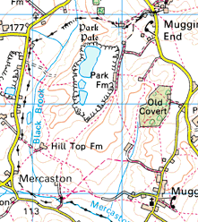


Image produced from the Ordnance Survey Get-a-map service.
Image reproduced with kind permission of Ordnance Survey
and Ordnance Survey of Northern Ireland.
Image reproduced with kind permission of Ordnance Survey
and Ordnance Survey of Northern Ireland.
The squares
on the map indicate photographed locations. Hold your mouse pointer over a square to see the path number and a brief description of the photograph.
Click to see the photograph(s).
- FP3: Path obstructed by substantial trees and shrubs (SOLVED) 2 photos
- FP4: Bridge tilting (SOLVED) 2 photos
- FP4: Gate tied shut (SOLVED) 2 photos
- FP6: Bridge overgrown (SOLVED) 2 photos
- FP7: Steep bank overgrown with gorse and brambles
- FP7: Collapsed stile (SOLVED) 2 photos
- FP7: Broken stile (SOLVED) 2 photos
- FP7: Path obstructed by barbed-wire fence (SOLVED) 2 photos
- FP7: Gate tied shut (2 photos)
- FP7: Gate tied shut (2 photos)
- FP8: Stile obstructed by pallets (SOLVED) 2 photos
- FP8: Path obstructed by gates and hurdles at Park Farm
- FP9: Obstructed by overgrown gate (SOLVED) 2 photos
- FP9: Difficult stream crossing (2 photos)
- FP12: Broken stile (SOLVED) 2 photos
- FP12: Path obstructed by pallets and barbed wire (SOLVED) 2 photos
- FP16: Squeeze stile obstructed (SOLVED) 3 photos