
Higher Hurdsfield
Footpaths in Higher Hurdsfield: 11 Photographed locations: 1
Authority: Cheshire East Council, Public Rights of Way Office
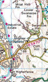


Image produced from the Ordnance Survey Get-a-map service.
Image reproduced with kind permission of Ordnance Survey
and Ordnance Survey of Northern Ireland.
Image reproduced with kind permission of Ordnance Survey
and Ordnance Survey of Northern Ireland.
The squares  on the map indicate photographed locations. Hold your mouse pointer over a square to see the path number and a brief description of the photograph.
Click to see the photograph(s).
on the map indicate photographed locations. Hold your mouse pointer over a square to see the path number and a brief description of the photograph.
Click to see the photograph(s).