
Footpath Photos
This section of my site shows photographs of problem areas, including problems that have been solved. The photos are available to the Highway Authority, the Peak & Northern Footpaths Society, and anyone else who's interested. Some footpath faults, such as missing signage, don't warrant photographs and aren't present here.
Footpaths are numbered within parishes. Click on a parish name or on a coloured area of map to see the photo listing for that parish.
Alternatively, click on the "Next" link at the top or bottom of the page, to visit all the pages in turn.
Three parishes around Macclesfield, Cheshire
- Green area: Bollington (56 paths, 19 photos)
- Blue area: Higher Hurdsfield (11 paths, 2 photos)
- Red area : Macclesfield (91 paths, 11 photos)
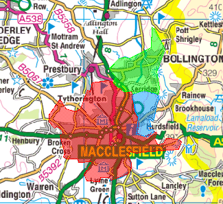
Image produced from the Ordnance Survey Get-a-map service.
Image reproduced with kind permission of Ordnance Survey
and Ordnance Survey of Northern Ireland.
Image reproduced with kind permission of Ordnance Survey
and Ordnance Survey of Northern Ireland.
Six parishes in the Derbyshire Dales
- Green area: Callow (7 paths, 1 photos)
- Blue area: Carsington (12 paths, 1 photos)
- Red area: Hopton (20 paths, 13 photos)
- Orange area: Ible (12 paths, 6 photos)
- Purple area: Ivonbrook Grange (2 paths, 2 photos)
- Yellow area: Wirksworth (87 paths, 9 photos)
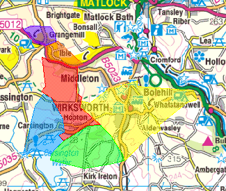
Image produced from the Ordnance Survey Get-a-map service.
Image reproduced with kind permission of Ordnance Survey
and Ordnance Survey of Northern Ireland.
Image reproduced with kind permission of Ordnance Survey
and Ordnance Survey of Northern Ireland.
Four parishes in the Amber Valley, Derbyshire
- Green area: Kedleston (5 paths, 7 photos)
- Blue area: Kirk Langley (39 paths, 51 photos)
- Purple area: Ravensdale Park (18 paths, 33 photos)
- Red area: Weston Underwood (49 paths, 70 photos)
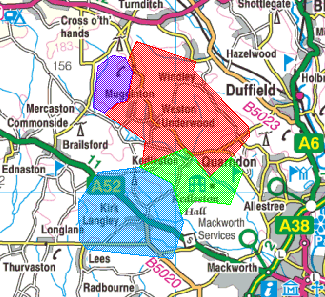
Image produced from the Ordnance Survey Get-a-map service.
Image reproduced with kind permission of Ordnance Survey
and Ordnance Survey of Northern Ireland.
Image reproduced with kind permission of Ordnance Survey
and Ordnance Survey of Northern Ireland.
Grand totals: 409 paths, 225 photos
Next: Bollington